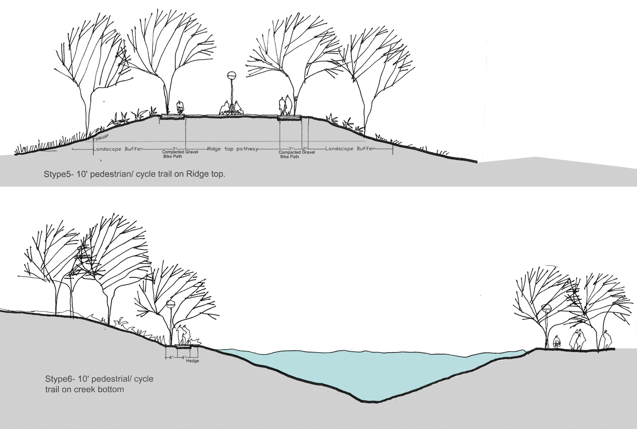
Urban Natural Drainage Channel Network, New Delhi
An Unexplored Potential
B-Arch Dissertation | T.V.B. School of Habitat Studies, India (1996)
This Bachelor of Architecture dissertation investigates the natural drainage channel network in Delhi, India, how conventional planning has ignored this network, and the subsequent impact on resulting urban development, both planned and unplanned. This planning approach has shaped professional and public attitudes toward the natural drainage system, into one of harmful indifference and neglect.
This study examines how the natural drainage network can be understood and utilized in order to achieve a more healthy and sustainable future, along with other long-term benefits, for the city and its inhabitants.
Full Abstract
The natural drainage channel network existing along with other natural features like hills, lakes, rivers systems etc., besides performing the purpose of draining the landscape, forms an important part of the physiography of the region. As a result, these features play a significant role in determining the origin and growth of settlements. Along with the change occurring in the character of the settlements from rural to urban, the role and significance of these features, besides their physical characteristics, also undergoes a change. It is observed that the way a city grows, in a planned or an unplanned manner, with respect to the natural lay of the land, greatly influences its form and functioning at various levels, ranging from making the city legible or enhancing its imageability to ensuring the existence of a healthy ecosystem with all the natural systems in order. Taking the case of Delhi, one realizes that the way this city has grown, as a result of the planning strategies adopted over the past several decades, no longer reflects the nature of the original landscape of the region. Natural features, like the Ridge and the river, instead of becoming the prominent and visible features of the city and determining its form and pattern of growth, have been completely sidelined and ignored. This planning approach, demonstrated through isolating these natural features, without attempting to integrate them into the city's structure has led to the development of an attitude of indifference towards them, both on the part of the planners as well as the residents, leading to their neglect and abuse.
As observed in the case of the drainage channels, with the neighborhoods being planned with their backs towards them, these channels have turned into carriers of solid wastes and effluents with squatter settlements proliferating along them. Examining the natural or inherent features of these channels, winch include their physical character i.e., their gradient, sectional profile and linearity as well as their role and significance as a part of the city's fabric; it is found that by capitalizing on the above features, the channels can be developed in various ways to achieve long term benefits for the city. But this is possible only if a comprehensive development strategy is formulated for the entire channel network instead of covering and building over them. This approach, which has primarily been adopted in response to the increasing deterioration occurring in the condition of the channels, though has helped in improving things to a certain extent, has failed to address or cater to the long term needs of the city. Due to a complete lack of understanding of the total scope of issues involved, the approach when analyzed, seems, not only a shortsighted one but also uncoordinated and disorganized, which, in order to fulfill the immediate needs of the various neighborhoods, has totally lost out on aspects relating to the city at a broader level.
This dissertation thus, attempts to explore alternate ways in which these channels can be utilized by understanding and taking advantage of their inherent characteristics, in order to achieve a more healthy and sustainable future along with other long term benefits for the city. Among others, the various possibilities discussed as a part of the dissertation proposal include; these channels being utilized as Transportation Corridors, Service Corridors, City Greens, and Urban Public Open Spaces. The analysis of the pros and cons of the above possibilities, in terms of the opportunities and constraints involved reveals that it is in fact possible to implement them at various levels through formulating a broad framework, in the form of a Master Plan at the broader city level. Within this plan various schemes for different stretches could be worked out depending on the area's needs or requirements and the feasibility of implementing the above proposals. Once the overall strategy at the macro level of the city, or the region, is formulated, enough flexibility can be provided at the micro level; where the various neighborhoods could be involved in planning and implementation of the schemes. This would not only ensure that the interests of the resident communities are safeguarded, but a sense of responsibility and concern for the city, and its environment, could also be inculcated within the community. By adopting the above approach not only could the backyards of the city be transformed into a means of achieving a more cohesive and legible urban fabric; apart from providing the city with an efficient and a more ecologically sound and sustainable environment, but also the residents of the city could be brought together to interact among themselves and use the city, while contributing to its welfare.


Rehabilitation of Evacuee Community, Delhi
Ward VIII (Shahjahanabad) in the M.S. Road Area
B-Arch Thesis | T.V.B. School of Habitat Studies, India (1996)
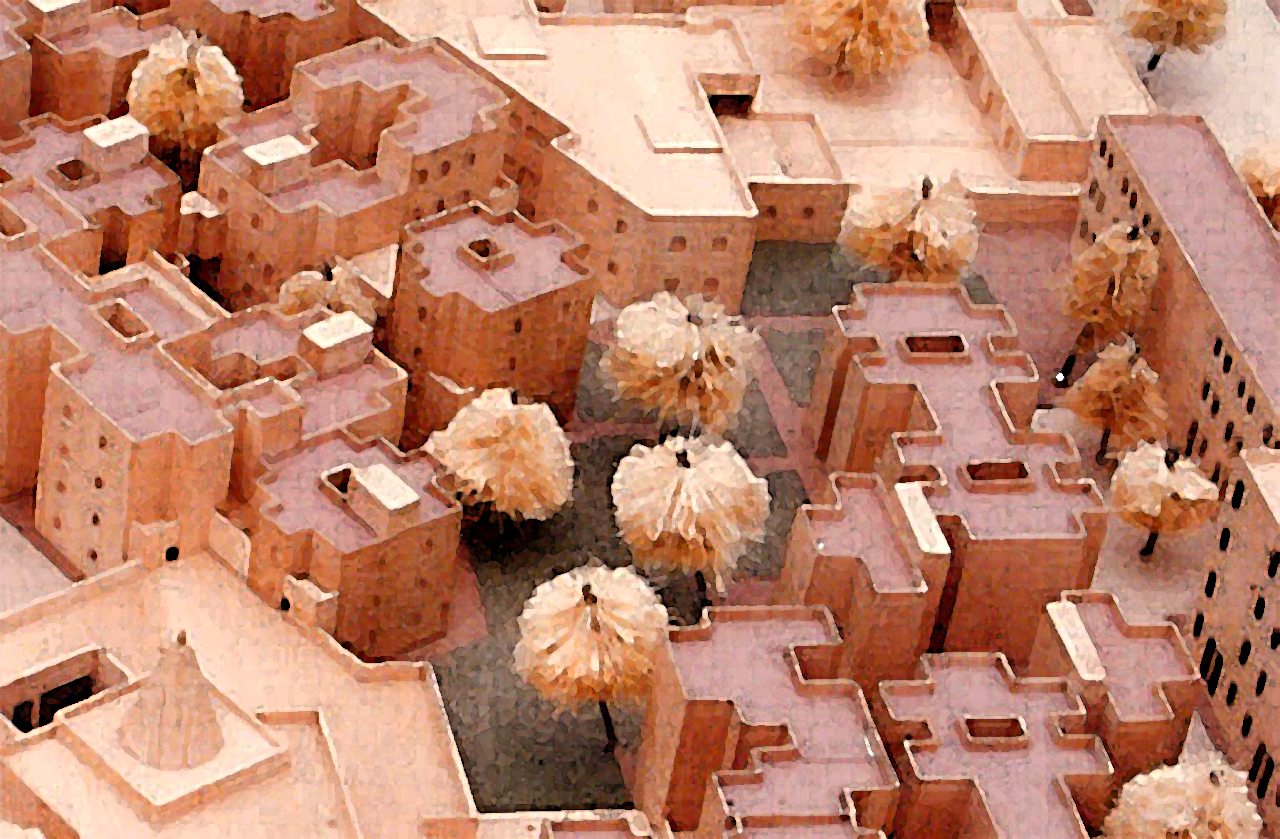
Through taking up this project for my undergraduate design thesis, I attempted to critically review the redevelopment strategies adopted by the planning authorities for the historic walled city of Delhi and its environs. This effort was undertaken as part of examining the options available for rehabilitating the residents of the walled city, in order to improve their living environment without disrupting their lifestyle in any other way. Here the basic aim was to develop an appropriate approach which would look beyond the physical issues concerning the inner city rehabilitation and specifically address the problem of resettlement of the walled city residents, as a part of a holistic redevelopment and renewal strategy.
Apart from trying to explore the planning and design aspects related to the study, an attempt was made to redefine the housing paradigm for the urban poor, such that it is centered on involving a participatory approach. As part of this approach, the thesis tried to explore the potential role of an architect as a professional amongst a variety of actors playing their roles, either independently or in conjunction with each other.
The case study undertaken formed a part of the M.S. Road area redevelopment study, where approximately 10 acres of land was being handed over to the “slum wing” of the Delhi Development Authority (DDA) for providing permanent accommodation to the evacuee families from Chowk 4&5 and Turkman Gate area, located in the walled city. These families were residing in temporary (transient) housing (accommodation) located in the M.S. Road area, just outside the walled city of Shahajahanabad. Though the above case was treated by the DDA as a one off situation involving relocation of families as a part of redeveloping the area (through demolition and rebuilding), a case was being made to develop such a methodology at an broader level for dealing with the redevelopment of the properties which have been declared “dangerous or unfit for human habitation” within the walled city.
There were a number of issues of varying degree of complexity that this thesis attempted to address along with proposing a design solution.
- Review of existing policies and practices adopted by the planning authorities for providing shelter to the urban poor particularly in the context of inner city.
- Critical evaluation of the redevelopment scheme for the area in question in terms of its land use distribution, density and its response to its surrounding context consisting of highly developed areas with a strong historical significance for both the old and the new city.
- Formulating a strategy and a programming design brief through involving the resident community in both the planning and implementation phase of the proposal.
- Examining design related issues of optimum density, amount of built up area per unit, typology of units, provision for incremental growth etc., along with proposals regarding the allotment and occupancy of the units.
Thus the thesis tried to challenge the traditional approach that had been adopted by planning authorities and regulatory agencies in Delhi. Based on research into and documentation of past experiences, it was determined that these approaches have created more problems rather than solve the issues at hand. The thesis proposed a more humane and people-based participatory approach to improving the habitat conditions for the evacuee community. It explored ways and means of providing for the rehabilitation of the evacuees of the inner city by formulating a design brief and program that not only caters to the needs of the target group but also addresses the site for the new housing within its historic, physical and social context.


Dilemmas of Tourism and Development in Khajuraho
Aiming for Sustainability through Participatory Resource Management
M-Phil Thesis | University of Cambridge, U.K. (1999)
The aim of this dissertation is to understand the conflicts of tourism and development in the World Heritage Site of Khajuraho and to deconstruct and define the notion of sustainability as it applies in the above context. Khajuraho is a small settlement in the state of Madhya Pradesh in Central India which has become an international tourist destination owing to its unique architectural heritage consisting of temples dating back to the 10th-11th century. While a lot has been written about Khajuraho per se, most of the literature is dominated by descriptions of the art and architecture or the historical legacy of the temples along with the myths and legends surrounding them. This study, besides revealing the lesser known aspects about Khajuraho, attempts to contribute to the existing literature on tourism and development in the Third World, by using the framework of participatory resource management to understand how the abstract notions of sustainability might be grounded in reality and practically understood or achieved in a given context.
In order to achieve the above objectives, the methodology of stakeholder analysis was adopted for which a field trip was undertaken, timed so as to coincide with an year long millennium festival being hosted in Khajuraho. A qualitative analysis was carried out through participant observation and in- depth interviews conducted with the entire range of stakeholders identified. In addition to carrying out the stakeholder analysis, meetings were organized and discussion held with key informants in smaller focus groups to triangulate and cross-check views expressed in the interviews.
The existing situation analysis and discussion with the stakeholders and key informants revealed that, while tourism is an important industry in Khajuraho, the way it has been structured and is being managed presently leads to little benefit actually trickling down to the local community. Moreover, even the resources (cultural and natural) that the industry and the community are dependent on are not being holistically conceived or managed. While on one hand there is a tremendous pressure on the local resources with the industry trying to capitalize on whatever little there is available, on the other the local community is getting more and more alienated from their own resources leading to a situation characterized by ever widening economic and socio-cultural disparity between the two. Under these circumstances it is suggested that instead of promoting tourism or 'developing' Khajuraho as a 'model destination' for tourists, priority should be given to investing in participatory natural and cultural resource management and community development so that the existing disparities are narrowed down, the condition of the local community and the resource they depend on is improved and the overall ethos of the heritage site along with its physical and cultural context is rejuvenated. It is argued here, that the only way to truly conserve and sustainably manage the resources is not by excluding or alienating the people who depend on or use the resources, but to make them realize that the resources belong to them and to revitalize the resource base is crucial for the people's own sustenance. It is therefore concluded that instead of trying to promote or sustain tourism, there is need to sustain the resources (natural & cultural) and the livelihood of the community as a precondition for achieving sustainable development in the context of Khajuraho. Thanks to the organization of the millennium there is widespread realization amongst the majority of stakeholders of the issues involved. What is needed now is a structuring of priorities and creation of an awareness among the most marginalized of the stakeholders on why and how they could contribute in the attempt to achieve long term sustainability.


Irwine Studio, Los Angles
Master plan for Irwine Township
Washington University, St. Louis (Fall 1999)
Studio Background and Context
The Studio focused on a site for a proposed 3000-acre township development was situated approximately 40 miles southeast of downtown Los Angeles, near the Santa Ana mountains in Orange County, adjacent to the EI Toro Marine Base, which was slated for closure. The studio focused on the design of village centers and building elements in and near these centers. Use was made of master planning studies and land use programming recommendations generated by the developer, the Irvine Company, as the basis for the design proposals.
The Irvine Company (TIC), was involved in the project throughout the semester, providing programming information, planning expertise and critiques on the work produced by the studio.
Although the project site was large in scale and complexity, the studio structure was intended to culminate in the production of very specific design proposals. Thus while the first half of the semester dealt with the development of the design of the village centers, the second half dealt with the design of more specific building types within them.
The Design
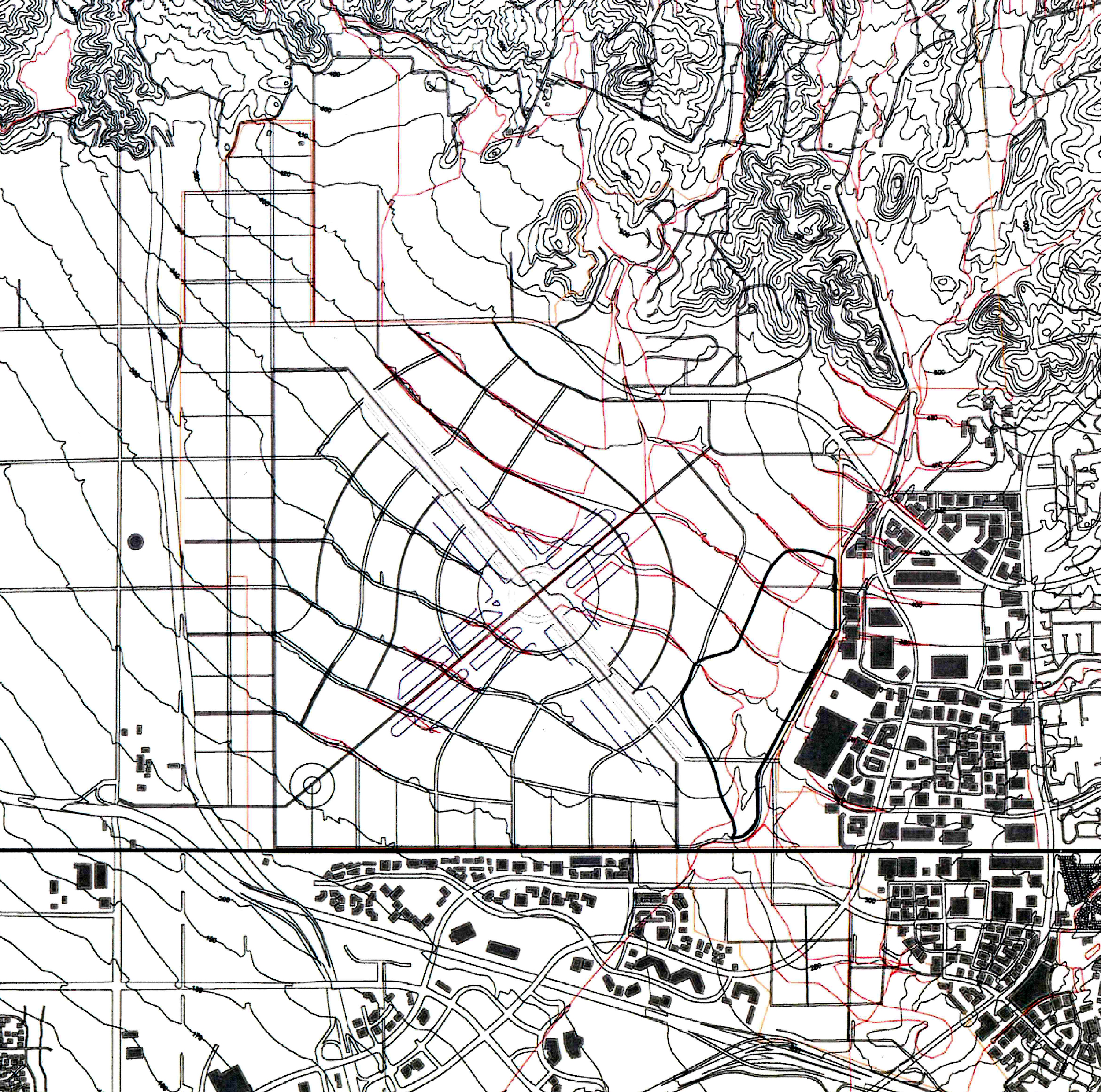
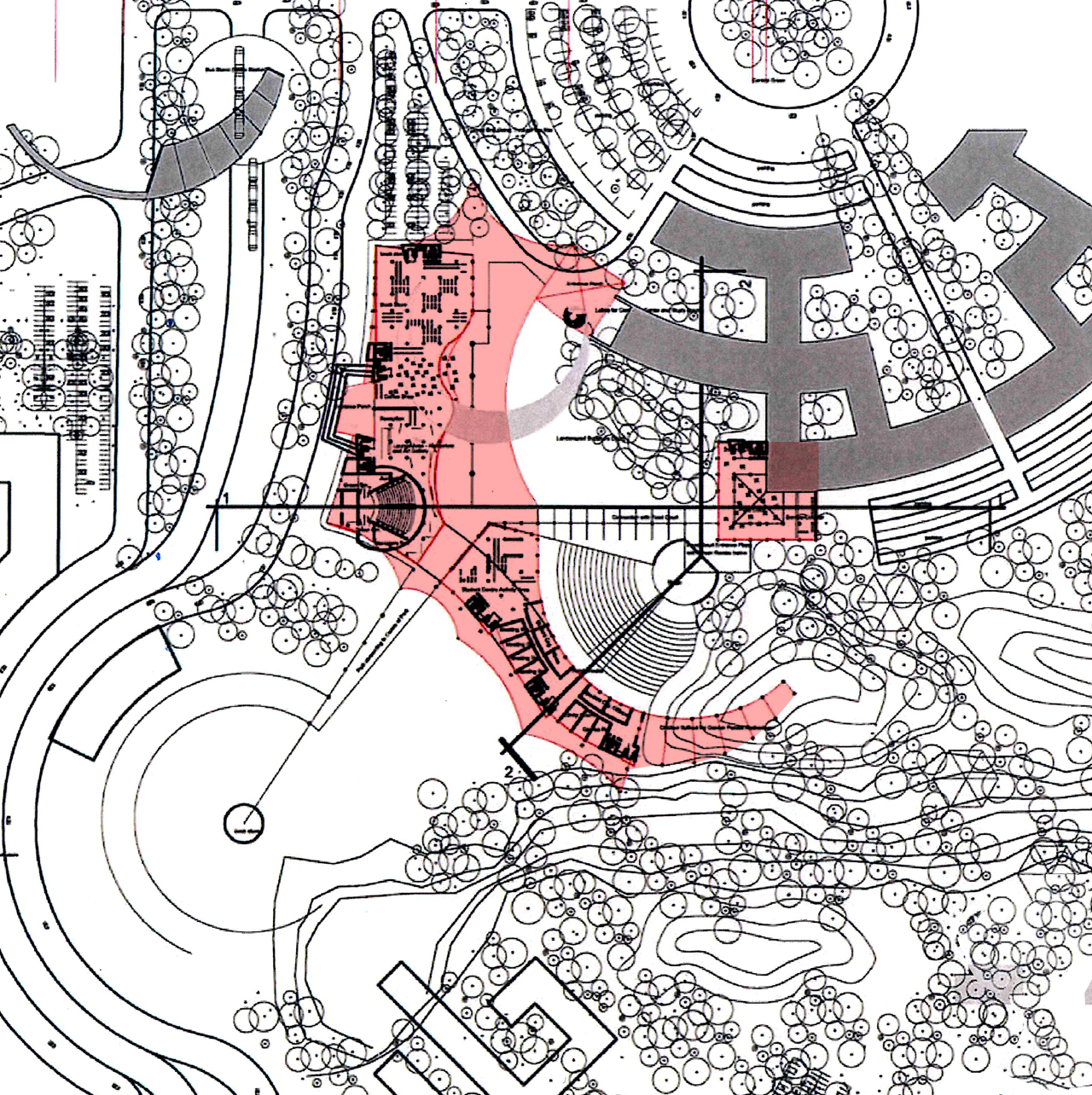
At the Master Plan level the design emphasized retaining the natural character of the site wherein the contours and the natural drainage corridors on the site largely dictated the settlement pattern. The axis formed by the runways was notionally retained as a part of fabric of the settlement, wherein the intersection of the two axes formed the core of the settlement around which the major institutional and commercial activities were organized.
This theme of letting the landscape guide the development was carried down to the district level. Within the district plan, a student center was further detailed out as part of the second stage of the project. This building was essentially designed as a free tensile form within the landscape wherein the structure of the building reflected the intended lightness. The integration of the building with the landscape and the fusion of the inside and the outside spaces was addressed through careful modulation of the building materials and its form.



Chinatown Studio, Chicago
Master plan for Chinatown Neighborhood
Washington University, St. Louis (Spring 2000)
Studio Background and Context
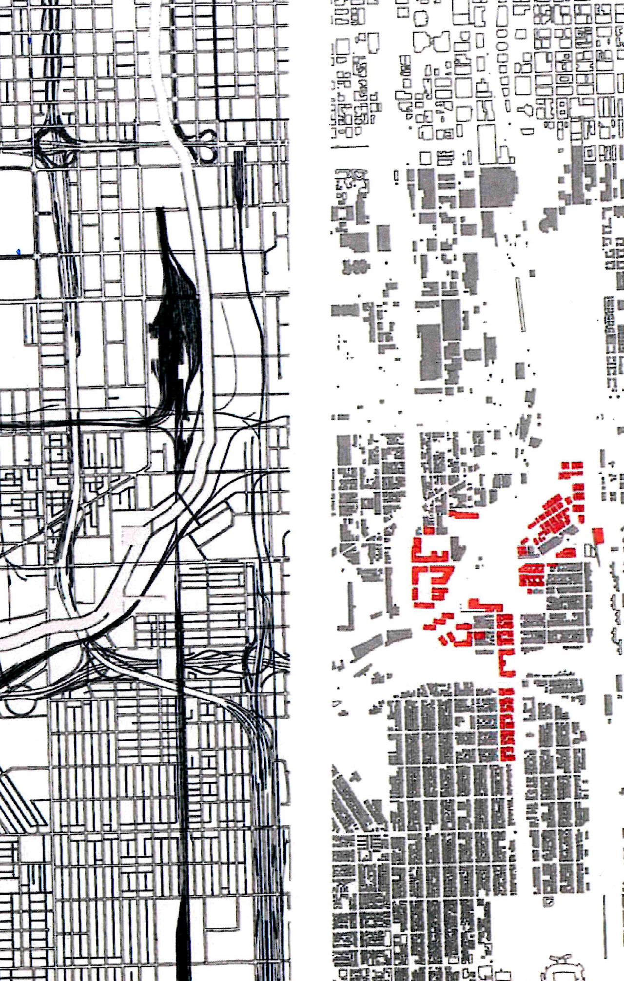
While the Chinese community has been in Chicago since 1870's, recently after years of static growth, the community increased in population and migrated into the neighborhoods surrounding Chinatown. The resulting larger Chinatown area thus became the new focus area for cohesive development and a unified Chinese community, which included Industrial uses along the rail tracks and Chicago River; with commercial uses focused along the main access roads Cermak and Wentworth; a few open spaces scattered throughout the area; and a majority of residential uses.
The Chinese American Service League in Chicago, who was the clients for the project, had developed a set of goals and objectives for an urban design master plan for the area between Chinatown and the neighboring area of Bridgeport. This included the program of developing a community center, park and a new neighborhood on an old industrial site adjacent to the Chicago River.
The Design
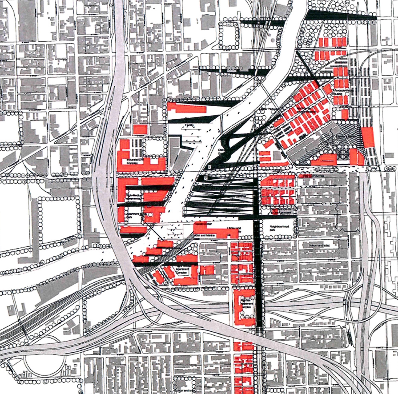
Based on extensive analysis of the site and its context, the opportunities and constraints were identified for the project. The river flowing across the site and connecting the downtown to Chinatown and beyond was conceived as the revitalization corridor for the neighborhood. An open space framework was created, consisting of green corridors, which linked the river to the neighborhood patches to form a cohesive matrix.
The other interventions included the downgrading of the raised railway platform and interception of Canal Street to give the River a better access from the neighborhoods. Also better connections were developed between the old and new sections of Chinatown through reinforcing Cermak.
The main organizing principle was the introduction of green fingers of the riverine landscape which penetrated into the urban fabric at various levels.
The design was detailed out to the scale of a district and design guidelines were developed to support the buildings, streets and open spaces typologies.


Sustainable Development though Eco-Planning, St. Louis
Case Study of the Meramec Sub-Watershed
MAUD Thesis | Washington University, St. Louis (2000)
The thesis aims to ground the notion of sustainability or sustainable development as interpreted in the field of ecological design, using a given a site along the Meramec River in St Louis County and a prescribed development program, in order to demonstrate an ecologically sensitive approach to design. This privately owned 62 acre site ispart of a larger watershed draining to the River slated for mixed used development consisting of 80 single family houses, a 200 room assisted living facility for the elderly, a 125 room hotel, a service station, retail and office buildings and two outlots 1.5 acres each. The study tries to build a theoretical framework to understand the different aspects of the problematic and how they are all tied up together as a system to aid the formulation of an appropriate intervention. The study in this process attempts to address a number of environment and development practice related issues, which emerge from the lack of congruence between the natural and manmade fabric of contemporary urban and suburban neighborhoods. The study primarily involves understanding the principles of landscape ecology at scales ranging from regional to local and ascertaining parameters through analysis and recombination of accepted methods to arrive at a methodology of ecological design. Thus the thesis, on the whole, tries to explore the relationship of design at the local site level to the analysis/ planning process at an overall level. It not only examines specific ecological issues as they relate to the process but also uses a set of explicit assumptions/ principles for ecologically sensitive design.
Various theories and principles existing in the field of ecological planning/development proposed or researched by theorists like Ian McHarg, Richard Forman, Fredrick Steiner etc. have been adopted for directing the research from the stage of formulating the relevant questions to that of finding appropriate answers to each one of them. The methodology adopted for the study has therefore been divided into the following stages, wherein the decisions made at each stage are based on either the guiding principles adopted or on factual data collected which further informs the next stage of the process:
- Construction of a theoretical framework to ground the theories of sustainability using the methods defined within the field of ecological planning taking the watershed as a unit for ecological planning.
- Following the establishment of the framework for defining the various scales on which the site and its context need to be understood, the McHargian layer cake model is adopted to analyze the site at the regional, landscape and local watershed level using secondary data sources.
- The different layers of the interpreted information are then overlaid in order to develop a comprehensive suitability map which grades the entire watershed area into zones varying from the least to the most suitable both in terms of the land use type and scope for building.
- This suitability analysis is combined with the programmatic and strategic response to the site context and translated into an illustrative master plan for the sub-watershed area, based on certain design concepts and principles.
- The residential district outlined in the illustrative master plan is then further detailed out to demonstrate the actual spatial characteristics of the settlement in terms of how the built form relates to the surrounding landscape and how both compliment each other to give a definite character to the ‘place’.
- The detailed plan for the residential district is further substantiated by design of typologies for the built-form, streets and open spaces along with developing specific design guidelines for characterizing the development.

