Connect Kendall Framework Plan
Cambridge, Massachusetts
Charles River Watershed Association | 2014-2015
Competition Overview
The Connect Kendall Square Open Space Planning Competition was launched by the City of Cambridge’s Community Development Department in July 2014, to develop a plan to implement the vision for the entire open space network in Kendall Square and eastern Cambridge and vicinity. Four teams of finalists were charged with developing an open space plan framework guided by a vision and planning and design goals identified through a robust public process spearheaded by the City and the Eastern Cambridge and Kendall Square Open Space (ECKOS) Study Committee. Given the significance of the location of competition site on the Charles River and the critical need for re-establishing the physical and functional water and landscape connections between the open spaces and the River, CRWA was a part of three of the four finalist teams.
Connect Kendall Square was a departure from more traditional planning processes, and even unique among competition formats. The competition generated creative ideas and thinking on strategies to use open space and the public realm to better connect Kendall Square to surrounding neighborhoods, and also create a sense of place and identity. The goals of the framework plan included promoting complementary uniqueness, establishing activations strategies, building an identity, and elevating the user experience. The teams presented their framework plans to the competition jury and the general public in March, 2015. The team led by Richard Burck Associates was chosen by a six member jury after the culmination of a three stage process spanning eight months. The framework plan produced by the winning team will serve as a means of informing park designs, the character and role of both public and private open spaces in the area, and even decisions regarding infrastructure, city policy and future development.
Proposal: The Framework Plan
The framework plan presented by Richard Burck Associates is structured on better connecting the Charles River to Kendall Square, and then better connecting Kendall Square to its surrounding parks, neighborhoods and MIT. This layered effort encompasses organizing new urban form to feature open space connectedness, connecting a series of sustainable stormwater strategies, and developing strong pedestrian connections throughout the project area. This "dendritic" pattern overlaid on Kendall Square describes circulation moving in an increasing concentrated way to the Charles River. It's a pattern with historic roots rich with interpretive possibilities in connecting Kendall Square today.
The plan is based on robust set of strategies and design interventions to achieve compelling placemaking and greater connectivity within the project site and its environs. Recommendations to achieve this span everything from site design to park programming to municipal stormwater engineering. These various strategies face to the future to anticipate a richer, more livable Kendall Square and East Cambridge for generations to come. However, the roots of the effort start with the history of the site when the Kendall Square area was originally a large marsh adjacent to a tidal river. The site existed for millennia as a functioning wetland ecosystem prior to the beginning of European settlement a few hundred years ago.
As Boston and its surroundings grew from a fledgling colony to a network of bustling villages, changes came to the marshes of East Cambridge. An expanding network of paths, roads, and bridges – most notably spanning today’s Longfellow Bridge route – led to incremental filling of wetlands and open water to create land. The Industrial Revolution brought dramatic change to the site. Along the path of what may have been a naturally occurring estuary, the Broad Canal, a stone edged waterway was constructed to serve and allow expansion of Kendall Square’s industry. By the early 19th century, maps illustrate a tight pattern of canals, factories, warehouses, shops and homes.
Half a century ago, everything changed once again. Massive redevelopment projects leveled a slow-grown neighborhood and a landfilling effort shortened the Broad Canal substantially. New buildings and office parks were created on large super-blocks. Favoring motorized vehicles over pedestrians, these “redeveloped” blocks formed impenetrable edges up to a quarter-mile in length.
Today, substantial change is needed to make Kendall Square more livable, walkable, and equitable, but paying careful attention to lessons from the past, this Framework Plan represents an approach that is incremental, organic, and authentic. The team propose to borrow from history in freshly interpreted ways, reestablishing water as a basis of both sustainability and circulation while at the same time, seeking to weaken the scar tissue of super blocks, allowing finer grained circulation patterns to emerge through them. Our design concept is a combination of two related design efforts, the first being CREATE Kendall Square and the second, CONNECT Kendall Square.

Historic Evolution of Land and Water Interface in East Cambridge

Connect Water - Collect

Connect Water - Framework Theme

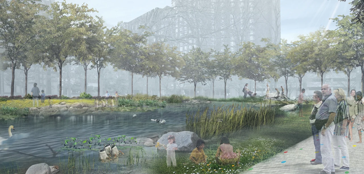
Connect Resources - Broad Wetland

Celebrate Water - Broad Wetland

Broad Wetland Section - Dry Weather

Broad Wetland Section - Wet Weather

Connect Water - Charles Island
